KNOWLEDGE BASE CONTENTS
Knowledge Base / Radar Enhances Situational Awareness / Multimode Capability
2.2 Multimode Capability
Multimode radar systems offer a variety of modes for collecting radar data and creating actionable intelligence in real time. These modes, including moving target indication and change detection, deliver data products relevant to a variety of ISR applications. Add in the capabilities of producing high-resolution imagery at great distances and covering large search areas quickly in a variety of available bands, and you have a powerhouse system equipped to give you exceptional situational awareness.
- High-resolution imagery at great distances
- Rapid wide area search
- Moving target detecting and tracking (land and maritime)
- Change detection
- Other modes for specific applications
High-Resolution Imagery at Great Distances
Unlike optical resolution, SAR image resolution does not degrade with increased distance. You can achieve the same image resolution whether the radar sensor is 10 km or 32 km away from the target, assuming the radar has enough power to illuminate at these distances. A SAR image is similar to a black-and-white optical image, except the pixels indicate the brightness, or magnitude, of reflection at that location. Range resolution is a function of the transmitted and received bandwidth, while azimuth resolution is a function of your synthetic aperture, which is created by “dragging” the antenna through space and time.
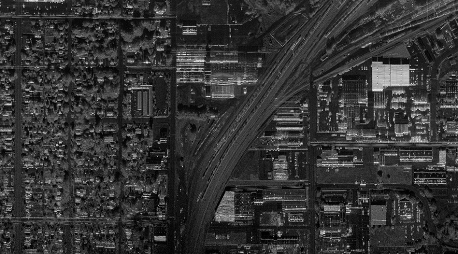
Long-Range SAR. In this urban image, roads and other features are easily distinguishable.
High-resolution SAR is a diverse capability with applications in nearly any situation in which details on the earth’s surface need to be observed (and sometimes even when details need to be observed below the surface). For example, SAR imagery has been used to monitor changes or anomalies in arctic sea ice.
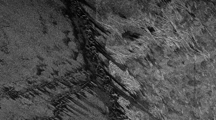
SAR Image of Sea Ice from IMSAR’s ONESAR at 0.1 m Range Resolution
Rapid Wide-Area Search
Both traditional and synthetic aperture radars have the ability to cover large areas in a relatively short amount of time. Moving Target Indication (MTI) performed by SAR is able to cover wide areas because they typically have large beamwidths, on the order of 5 to 20 degrees, which create a large footprint in a single look. By combining multiple looks in rapid succession, the radar can cover wide areas quickly. An Electronically Scanning Array, or ESA, is needed to rapidly collect these multiple looks, since an ESA has the ability to change beam location in fractions of a second.
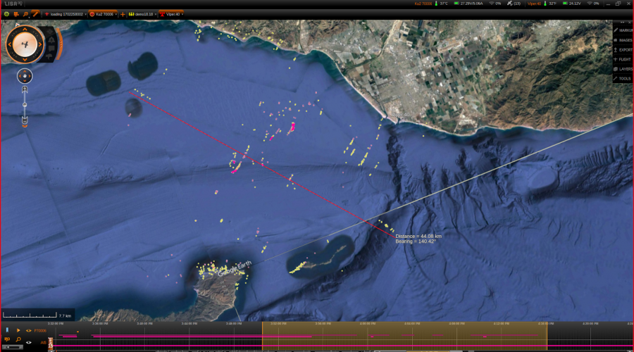
IMSAR Radar Wide-Area Search. IMSAR’s system software, Lisa 3D, interfaces with the radar to display radar data. Objects moving toward the sensor are marked in pink. Objects moving away from the sensor are yellow.
SAR systems can also cover wide areas using coarse-resolution mapping.This approach is typically reserved for ocean and littoral environments when looking for slow and small targets; however, it can also be used to image over land. Unlike camera systems, radar is able to detect objects smaller than imaging resolution cell size, or subpixel sized objects.
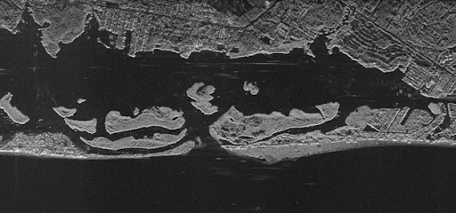
Wide-Area Search
Moving Target Detecting and Tracking
Through their MTI modes, SAR radars can detect abnormalities on land or sea. Once objects are detected, the MTI modes can use multiple detections to track the target to obtain speed and heading.
Land Targets: Ground and Dismount Moving Target Indication (GMTI/DMTI)
With GMTI/DMTI mode, operators/analysts can detect and track moving ground targets in real time, including both vehicles and dismounts. GMTI is performed by comparing the returns of the radar signal from multiple receive antennas, cancelling out the stationary background, and isolating the moving objects. GMTI outputs are simple dots that cue the operator where movement is occuring, thereby reducing the operator’s work load. GMTI processing can be especially helpful in the collection of accurate ISR in all weather, day and night, when other sensors fall short. By continuously updating radar images of a specific area, real-time geolocations of multiple targets can be obtained and displayed on a map or satellite image. When combined with SAR imagery and CCD/MCD, GMTI can be used to efficiently perform patterns-of-life analysis.
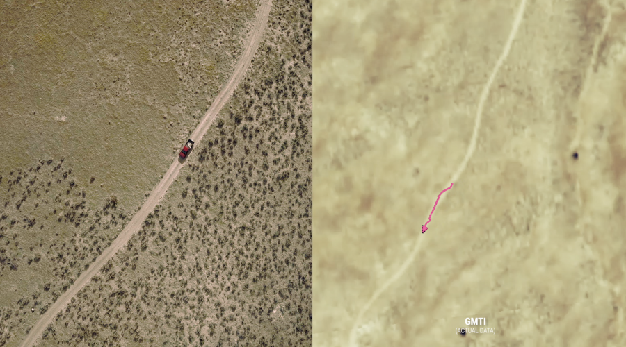
MTI Detects and Tracks Overlaid on an Optical Map. Actual optical imagery (left) and GMTI data overlaid on Google Earth imagery (right) of the same vehicle.
Maritime Targets: Maritime Moving Target Indication (MMTI)
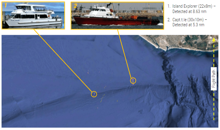
SAR radars have a moving target indication mode, MMTI, specifically optimized for operations over water. MMTI mode uses Doppler to automatically search for, detect, and track moving targets and other objects in maritime and littoral environments. MMTI can be used to perform a focused search by commanding the radar to continuously monitor a preselected area of interest, or perform a wide-area search in which the radar uses a scan pattern to optimize the search area. SAR sensors can search vast areas of ocean for moving targets, perform wide-area imaging to find stationary targets, and perform high-resolution imaging to collect detailed images of targets.
Change Detection
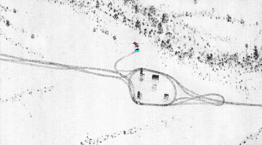
Subtle changes in an area can be difficult to detect from human observation or optical images alone. Because radar sees roughness, it can detect disturbances in surfaces, such as minute changes caused by tire tracks and footprints in the dirt, which might be unobservable by the human eye. In maritime environments SAR systems are capable of processing coherent change detection along beaches and shorelines to find ingress and egress points to the water. NOTE: CCD does not work over water because the surface of the water is in a state of constant change.
CCD compares multiple SAR images of the same area collected at different times and automatically detects and highlights changes that occurred in that area between the data collections. MCD highlights magnitude changes, such as vehicles that enter or leave the scene, while CCD highlights phase changes as subtle as vehicle tracks or footprints. CCD products display as black highlights against a faded white background and MCD products as blue (new) and red (fled) highlights.
Other Modes for Specific Applications
SAR systems are capable of several additional specialized radar data products. The following additional modes are available with IMSAR radars, but are not necessarily exclusive to IMSAR radars.
SAR Motion Video (SMV)
Produces a live stream of the radar imagery, which is replayable, and provides a context that might be lost in individual still images. The output of SMV is similar to that of Full Motion Video (FMV), although it typically updates at a slower rate.
SMV and Full-Motion Video (FMV) of the Same Intersection. SMV (left) supplements the imagery produced by FMV (right) by providing continuous, real-time sensor coverage when FMV cannot, such as during cloud cover, night skies, or Degraded Visual Environments (DVE).
ISAR
IMSAR has advanced its radars’ multimode capabilities to include a real-time Inverse Synthetic Aperture Radar (ISAR) processing mode, which will enable high resolution imaging of moving vessels for measurement and classification. The ISAR mode enhancement, in which two-dimensional, high resolution images of maritime targets can be generated, is a valuable advantage in maritime applications, since it relies on the motion of targets on water rather than the movement of the radar to generate images. This mode provides target imaging in all weather, which is especially important in maritime environments since they are notorious for poor weather conditions.
ISAR Data from Maritime Collection with the IMSAR NSP-7. These ISAR images (left: 0.1m resolution) and (right: 0.3m resolution) were taken of the craft pictured in the center, with the following specifications: 10,000′ AGL, 25-degree depression/grazing angle, 4 mile standoff range, sunny conditions.
Sector Scan
Sector scan mode is a subset of Moving Target Indication. This mode allows for a maximum amount of surface area to be covered by the radar, so it is especially useful for wide-area searches.
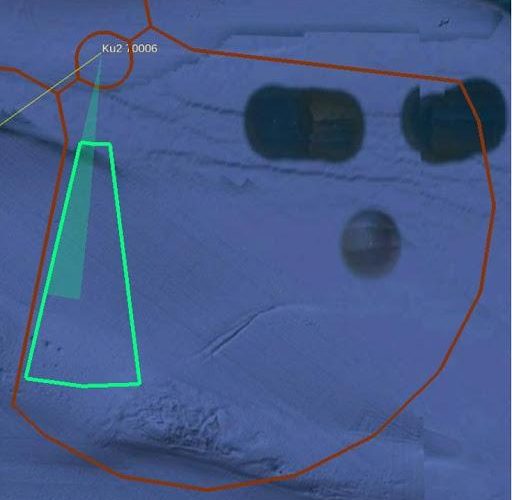
Sector Scan Mode. The red shape represents the Field of Regard for the radar, with the radar being located at the center of the small circle (upper left-hand corner). The green shading shows the radar’s current scanning area, and the green outline represents the sector scan area the radar is preset to cover.
FOPEN
Since foliage canopies create barriers that can reflect signals and prevent them from reaching the objects and terrain below, nefarious actors often conceal infrastructure and illegal activity below the canopy. Optical and infrared sensors do not penetrate through foliage and can even be reflected by other, less dense barriers including clouds and smoke. In low-frequency UWB radar systems, long wavelength signals naturally penetrate foliage and detect man-made objects, such as buildings and vehicles, directly through the foliage. FOPEN applications include stemming illegal activities such as deforestation and drug manufacturing and trafficking activity.
For more information, contact IMSAR sales@imsar.com.
Related Content
Updated May 14th, 2021
